Log in
All resources
Create a design
472 Free Images of German Language Maps
bibliothèque nationale de france
carte generale du tres-haut, tres-puissant et tres chrestien royaume de france
topographisch, oeconomisch und militaerische charte von mecklenburg, schwerin und ratzeburg
topographisch, oeconomisch und militaerische charte des herzogthums mecklenburg schwerin and des fürstenthums ratzeburg - schmettau
tranquillo mollo
eran laor cartographic collection
baroque
matthäus merian
general charte der in den herzoglich bremen - und verdenschen aemtern und gerichten ottersberg, osterholtz, lilienthal, bremervörde, rotenburg und achim belegenen mööre, und der seit 1750 darin... - btv1b531196435
willem albert bachiene
topographisch, oeconomisch und militaerische charte des herzogthums mecklenburg schwerin and des fürstenthums ratzeburg - schmettau
topographisch, oeconomisch und militaerische charte von mecklenburg, schwerin und ratzeburg
topographisch, oeconomisch und militaerische charte des herzogthums mecklenburg schwerin and des fürstenthums ratzeburg - schmettau
topographisch, oeconomisch und militaerische charte von mecklenburg, schwerin und ratzeburg
topographische karte der gegenden wiens... - m. ragginger, del... - btv1b530275792
tranquillo mollo
topographisch, oeconomisch und militaerische charte des herzogthums mecklenburg schwerin and des fürstenthums ratzeburg - schmettau
topographisch, oeconomisch und militaerische charte von mecklenburg, schwerin und ratzeburg
topographisch, oeconomisch und militaerische charte des herzogthums mecklenburg schwerin and des fürstenthums ratzeburg - schmettau
topographisch, oeconomisch und militaerische charte von mecklenburg, schwerin und ratzeburg
topographisch, oeconomisch und militaerische charte des herzogthums mecklenburg schwerin and des fürstenthums ratzeburg - schmettau
topographisch, oeconomisch und militaerische charte von mecklenburg, schwerin und ratzeburg
topographisch, oeconomisch und militaerische charte des herzogthums mecklenburg schwerin and des fürstenthums ratzeburg - schmettau
topographisch, oeconomisch und militaerische charte von mecklenburg, schwerin und ratzeburg
topographisch, oeconomisch und militaerische charte des herzogthums mecklenburg schwerin and des fürstenthums ratzeburg - schmettau
topographisch, oeconomisch und militaerische charte von mecklenburg, schwerin und ratzeburg
topographisch, oeconomisch und militaerische charte des herzogthums mecklenburg schwerin and des fürstenthums ratzeburg - schmettau
topographisch, oeconomisch und militaerische charte von mecklenburg, schwerin und ratzeburg
topographisch, oeconomisch und militaerische charte des herzogthums mecklenburg schwerin and des fürstenthums ratzeburg - schmettau
topographisch, oeconomisch und militaerische charte von mecklenburg, schwerin und ratzeburg
topographisch, oeconomisch und militaerische charte des herzogthums mecklenburg schwerin and des fürstenthums ratzeburg - schmettau
topographisch, oeconomisch und militaerische charte von mecklenburg, schwerin und ratzeburg
topographisch, oeconomisch und militaerische charte des herzogthums mecklenburg schwerin and des fürstenthums ratzeburg - schmettau
topographisch, oeconomisch und militaerische charte von mecklenburg, schwerin und ratzeburg
topographisch, oeconomisch und militaerische charte des herzogthums mecklenburg schwerin and des fürstenthums ratzeburg - schmettau
topographisch, oeconomisch und militaerische charte von mecklenburg, schwerin und ratzeburg
topographisch, oeconomisch und militaerische charte des herzogthums mecklenburg schwerin and des fürstenthums ratzeburg - schmettau
topographisch, oeconomisch und militaerische charte von mecklenburg, schwerin und ratzeburg
topographisch, oeconomisch und militaerische charte des herzogthums mecklenburg schwerin and des fürstenthums ratzeburg - schmettau
topographisch, oeconomisch und militaerische charte von mecklenburg, schwerin und ratzeburg
topographisch, oeconomisch und militaerische charte des herzogthums mecklenburg schwerin and des fürstenthums ratzeburg - schmettau
topographisch, oeconomisch und militaerische charte von mecklenburg, schwerin und ratzeburg
charles william meredith van de velde
eran laor cartographic collection
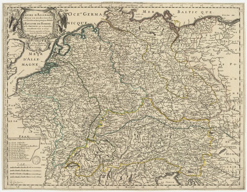
l'empire d'allemagne divisé en ses dix cercles, et ces cercles en leurs principaux estats, principautés et souverainetés ecclésiastiques, laiques et villes impériales avecq le royaume de boheme et les... - btv1b53202355w
sanson maps of the circles of germany
bibliothèque nationale de france
joachim ottens
leonard schenk jansz.
maps from gallica
17th-century maps of vienna
maps by nicolaes visscher i
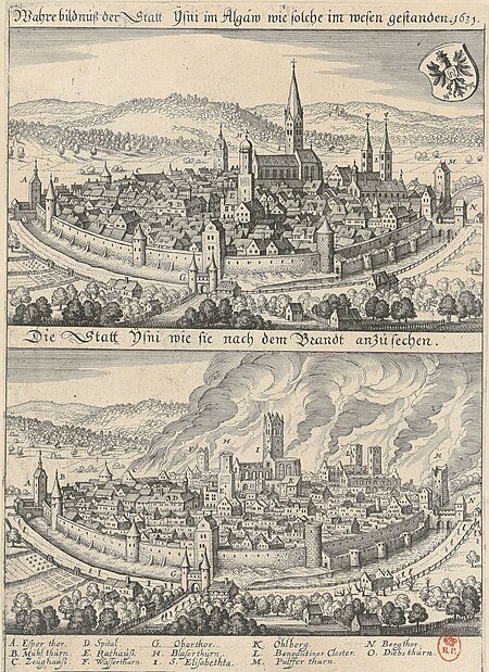
1631 stadtbrand von isny im allgäu
baroque
general charte der in den herzoglich bremen - und verdenschen aemtern und gerichten ottersberg, osterholtz, lilienthal, bremervörde, rotenburg und achim belegenen mööre, und der seit 1750 darin... - btv1b531196435
bibliothèque nationale de france
old maps of regensburg
baroque
general charte der in den herzoglich bremen - und verdenschen aemtern und gerichten ottersberg, osterholtz, lilienthal, bremervörde, rotenburg und achim belegenen mööre, und der seit 1750 darin... - btv1b531196435
bibliothèque nationale de france
general charte der in den herzoglich bremen - und verdenschen aemtern und gerichten ottersberg, osterholtz, lilienthal, bremervörde, rotenburg und achim belegenen mööre, und der seit 1750 darin... - btv1b531196435
bibliothèque nationale de france
general charte der in den herzoglich bremen - und verdenschen aemtern und gerichten ottersberg, osterholtz, lilienthal, bremervörde, rotenburg und achim belegenen mööre, und der seit 1750 darin... - btv1b531196435
bibliothèque nationale de france
engravings by matthäus merian
baroque
eran laor cartographic collection
willem albert bachiene
eran laor cartographic collection
willem albert bachiene
bibliothèque nationale de france
tranquillo mollo
carte generale du tres-haut, tres-puissant et tres chrestien royaume de france
bibliothèque nationale de france
carte generale du tres-haut, tres-puissant et tres chrestien royaume de france
bibliothèque nationale de france
carte generale du tres-haut, tres-puissant et tres chrestien royaume de france
bibliothèque nationale de france
bibliothèque nationale de france
tranquillo mollo
carte generale du tres-haut, tres-puissant et tres chrestien royaume de france
bibliothèque nationale de france
carte generale du tres-haut, tres-puissant et tres chrestien royaume de france
bibliothèque nationale de france
carte generale du tres-haut, tres-puissant et tres chrestien royaume de france
bibliothèque nationale de france
carte generale du tres-haut, tres-puissant et tres chrestien royaume de france
bibliothèque nationale de france
carte generale du tres-haut, tres-puissant et tres chrestien royaume de france
bibliothèque nationale de france
carte generale du tres-haut, tres-puissant et tres chrestien royaume de france
bibliothèque nationale de france
carte generale du tres-haut, tres-puissant et tres chrestien royaume de france
bibliothèque nationale de france
eran laor cartographic collection
willem albert bachiene
eran laor cartographic collection
willem albert bachiene
carte generale du tres-haut, tres-puissant et tres chrestien royaume de france
bibliothèque nationale de france
carte generale du tres-haut, tres-puissant et tres chrestien royaume de france
bibliothèque nationale de france
carte generale du tres-haut, tres-puissant et tres chrestien royaume de france
bibliothèque nationale de france
carte generale du tres-haut, tres-puissant et tres chrestien royaume de france
bibliothèque nationale de france
carte generale du tres-haut, tres-puissant et tres chrestien royaume de france
bibliothèque nationale de france
carte generale du tres-haut, tres-puissant et tres chrestien royaume de france
bibliothèque nationale de france
carte generale du tres-haut, tres-puissant et tres chrestien royaume de france
bibliothèque nationale de france
carte generale du tres-haut, tres-puissant et tres chrestien royaume de france
bibliothèque nationale de france
carte generale du tres-haut, tres-puissant et tres chrestien royaume de france
bibliothèque nationale de france
carte generale du tres-haut, tres-puissant et tres chrestien royaume de france
bibliothèque nationale de france
carte generale du tres-haut, tres-puissant et tres chrestien royaume de france
bibliothèque nationale de france
carte generale du tres-haut, tres-puissant et tres chrestien royaume de france
bibliothèque nationale de france
carte generale du tres-haut, tres-puissant et tres chrestien royaume de france
bibliothèque nationale de france
carte generale du tres-haut, tres-puissant et tres chrestien royaume de france
bibliothèque nationale de france
carte generale du tres-haut, tres-puissant et tres chrestien royaume de france
bibliothèque nationale de france
a plan of the operations of the king's army under the command of general sr. william howe, k.b. in new york and east new jersey, against the american forces commanded by general washington, from the 12th. of october, to the 28th. of november 1776
german-language maps
bibliothèque nationale de france
tranquillo mollo
maps by thomas nast
1872 maps of texas
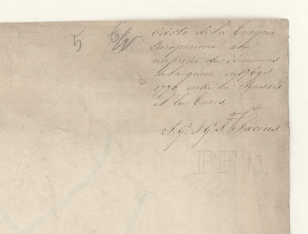
carte de la turquie europeene avec un precis des evenemens de la guerre en 1769 et 1770 entre les russes et les turcs - dressée... par i.g. et g.s. facius - btv1b53099612p
bibliothèque nationale de france
carte de la turquie europeene avec un precis des evenemens de la guerre en 1769 et 1770 entre les russes et les turcs - dressée... par i.g. et g.s. facius - btv1b53099612p
bibliothèque nationale de france
bern city map of 1638 by matthäus merian
baroque
kriegs theater zwischen russland und der ottomanischen pforte... - herausgegeben bey t. mollo in wien - btv1b53119380b
tranquillo mollo
old maps of mainz
baroque
l'empire d'allemagne divisé en ses dix cercles en leurs principaux estats. le royaume de bohême et les provinces qui en dépendent - nouvellement reveu et corrigé par le sieur sanson... ; lud. cordier... - btv1b532023318
sanson maps of the circles of germany
carte de l'amérique septentrionale by guillaume delisle (1700)
1700 maps of north america
history of philadelphia
lithographs
german renaissance
1744 fleurons
diagrams of direction road signs of germany
pd germany
401 - 472 of 472
/ 5